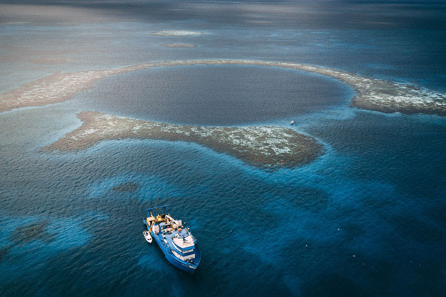
In November of 2018 Aquatica Submarines shipped a three person submarine, Stingray 500, across frosty North America on the back of a truck then over the rolling winter seas of the Gulf of Mexico to Belize aboard the R/V Brooks McCall. Our destination was a site located 7 miles into Lighthouse Reef – a perfect sinkhole in the ocean known as the Great Blue Hole.
We traveled to this UNESCO World Heritage site to explore and document a geologic phenomenon in support of conservation science and to conduct outreach. Our mission was two fold, map the Great Blue Hole using high resolution sonar and take people worldwide on this journey with us on broadcast TV. Everything we collected, from CTD data and dissolved oxygen content, to video footage and experiential data, gives us the fodder we need to tell a story about an unusual place on our planet most people have never seen, until now.
Geology from not-a-geologist
Over the past 14,000 years the polar ice caps, formed during the last glacial maximum, have thawed and raised sea level in steps. These defrosting events are captured in a stone record of an oceanic sinkhole in Belize. The aptly named Great Blue Hole is a collapsed cave, filled with stalactite caverns, and built up from layers of fine limestone and rougher calcium carbonate walls. The stepped rise of sea level can be seen in the form of terraces carved deeply by erosion into the otherwise vertical rock walls. Straight vertical stretches of wall are free of erosion because sea level rose rapidly during a few brief decades between each step. As each melting event took place sea level rose dramatically, as much as 100 feet in 100 years, followed by centuries of stability. Preserved from the disturbance of time, and isolated in the darkness, the hole holds clues to a very natural part of our planet’s life cycle. It’s these terraces and stalactites we set out to map.
Sight through Sound
Along with us on the Expedition was Mark Atherton, a well respected sonar expert with Kongsberg Mesotech, author of Echoes and Images, and all around great company onboard a ship for 3 weeks. Kongsberg generously loaned us an array of sonar units and accompanying sonar expertise to create the 3D map we set out to complete. We deployed a Dual Axis Sonar (DAS) from our surface support vessel Topside (affectionately referred to as DAS Boat). This unit was used to scan the entire hole in high resolution from the surface. We also mounted a multibeam sonar directly to the front of the submarine and used it for navigation.
With a variety of sonar heads, used sequentially over the course of the Expedition, we’ve been able to create a high resolution, 3 dimensional sonar image of the interior of the Great Blue Hole. Some of the targets we were particularly interested in studying in detail were the stalactite caverns from 130 feet to 160 feet deep, formed back when sea level was 500 feet lower and this was a dry cave. These enormous stalactites have now been entirely encrusted in marine growth.
We also observed a calcium carbonate layer at 290 feet where a great coral reef grew in what was then shallow Caribbean waters. We searched for evidence of stalactites near the bottom around 407 feet and found indications of small stalactite or stalagmite formations. These and faint flowstones have been mostly covered up by centuries of sand pouring into the hole, and will presumably be entirely covered in sand as the hole slowly fills in.
In addition to the sonar map, we deployed a CTD to measure Conductivity, Temperature, and Depth as well as dissolved oxygen. Collected data show that below the hydrogen sulfide layer at 300 feet the bottom is completely anoxic – there’s not a drop of oxygen down there. This is also evidenced by the “conch graveyard,” a stretch of the blue hole where we observed hundreds of dead conch that had presumably fallen in to the hole and been unable to escape the steep walls or survive long without oxygen. It was otherworldly down there and our data is one more way to share this revelation.
Conch Graveyard
As pilots we navigate by sight and sonar because visibility is often limited to the max reach of our lights combined with the turbidity of the water, anywhere between 0-80 feet. We create mental maps of the places we’ve been and use dead reckoning to navigate around our dive site. We sometimes give little areas of our dive sites unique names, so that we can meet up easily or describe how to get somewhere to the next pilot. Kind of like telling your buddy how to find your house in heavy fog, “turn left after the lightning strike tree, then it’s the red mailbox on the right.”
For example, 350 feet below the north entrance of the hole is a place we’ve internally named the Conch Graveyard – it’s a point of reference. Presumably, unsuspecting conchs (or other conch shell inhabitants) have been going just a little too close to the edge and falling into the hole at this entrance by the thousands. We can see each conch with little tracks back up the hill trying to escape, then a slide mark where it slid back down after presumably being asphyxiated in the anoxic environment. So much sand billows down the steep rim of the hole at this location that fallen conch must be getting covered up quickly, so the shear number of visible shells is a pretty good indicator that the conch population is healthy – it’s slightly morbid but describes something positive.
Diving in Acid
Hydrogen sulfide (H2S) is a foul smelling, colorless gas. It is toxic, flammable, and highly corrosive. There’s a thick layer of it around 300 feet deep in the Great Blue Hole we dove straight into. There is no circulation in or out of the hole, and our onboard CTD and dissolved oxygen sensor revealed what we had predicted, the bottom is completely anoxic. There’s not a drop of oxygen below the H2S layer.
Sulfur reducing and sulfate reducing bacteria living in hypoxic or anoxic environments, like this oceanic sinkhole, use sulfates to oxidize organic matter. Hydrogen sulfide is a waste product of this natural biochemical process. Another possible contributor to the H2S layer’s thickness and density could be the prevalence of sargassum seaweed. This brown algae contains a high concentration of sulfuric compounds and has been prolific across the caribbean in 2016 and 2018. I had the great privilege of diving with the founder of MarAlliance, Rachel Graham. She told me about a shark tracking project in which they found hammerhead sharks regularly visit the hole, along with reef sharks, and they’ll never swim into the H2S layer, they always stay just above it.
From a mechanical perspective, for the protection of our equipment, we learned that up to 0.5% H2S in solution is acceptable when it comes into contact with carbon steel surfaces, but 1.5% and greater is deleteriously corrosive. Our Stingray 500 is mostly aluminum, which is hardly affected by acidic H2S, however we have some painted steel components, and our partner diving vessel is painted carbon steel. Both subs were monitored rigorously for signs of corrosion and now that the Expedition is over we will maintenance them meticulously.
An Elegant Pair: Science and Experience
The predominant winds across the Great Blue Hole are from the East. Something we had come to know deeply as we waited out 5 high wind and weather days before being able to dive. Our initial descent into the hole was vertically down near the north entrance. We were looking for terraces and calcium carbonate layers, evidence of sea level rise over the past 14,000 years. Slowly we made our way down, expecting to find bottom around 420 feet or so. Unable to see through the hydrogen sulfide (H2S) layer, our altimeter indicated bottom much closer than we were expecting. Our slow descent through the opaque H2S layer brought us down on a berm of sand with a pointed ridgeline running along the edge of the hole. This ridgeline was only 320 feet deep meaning that this 100 foot tall berm forms where sand pours into the hole from the edges.
Between the rock wall and the berm, a trench runs most of the length of hole. However, on the northeastern edge there is no trench, the entire area is full of sand up to the top of the berm. It seemed odd at the time, piloting around the hole inside the trench and getting squeezed out the top while traversing towards the east then being able to descend back down into it as we passed to the southeast. It wasn’t until the post dive debrief that we arrived at the answer. We’d been watching the ship swing for days, planning for a complex launch procedure to safely deploy the submarines with a heavy easterly blowing. This eastern edge is the most filled in because this is the direction of the most prevalent wind. Wind driven waves push sand, and any unsuspecting conchs (see ‘Conch Graveyard’), into the hole and fill in the trench. Making this connection was like a mental light bulb turning on. It seems like a small detail but it’s a thousand tiny connections between the physics of a place and our experiences in that place that make exploration as valuable today as it’s ever been.